Camp Kodiak
All genders
Overnight camp
6 - 18 yrs
A message from our camp
Every camper deserves to experience a summer of fun, friends and success! Camp Kodiak groups each camper into the cabin group that will provide them with the best social fit that is also age appropriate. This increases the likelihood that campers will connect with each other, and develop meaningful friendships.
Our staff are taught to imbed social skills learning into everything we do! Because it is seamlessly integrated, the camper do not realize that they are receiving social skills lessons throughout the day.
By learning social skills in context, campers are better prepared to apply these skills successfully with greater independence.
Dave Stoch started camp in 1991, and my sisters and I are privileged to continue our dad's legacy. We are all certified teachers with decades of teaching and camp experience who have grown up in the camp environment.
As parents, we understand the responsibility and care that is entrusted to us, and we take that very seriously!
Camp Kodiak is our "home away from home" and we want to welcome more campers to find their new summer home!

About our camp
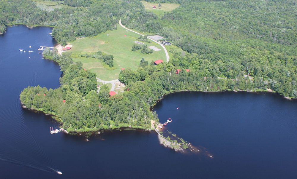
Camp Kodiak is Canada's premier overnight summer camp for children and teens with and without learning disabilities, ADHD, and ASD Level 1. Some of our highlights include: -social skills program -academic program -50+ activities -mature, professional staff -2:1 camper-to-staff ratio around camp & 3:1 camper-to-counsellor ratio in cabins -small cabin groups -comfortable cabins with electricity and full bathroom with shower -425 acres -over a mile of waterfront -2.5 hrs from Toronto, Ontario
Our programs
Our schedule includes a combination of pre-scheduled activities that campers attend with their cabin group and self-selected activities. This provides everyone with the chance to expand their horizons, push the limits of their comfort zone, explore new interest, and discover hidden talents! Our Leaders-in-Training (16 to 18 year-old campers) participate in leadership development workshops and have the opportunity to volunteer for a variety of leadership roles around camp. These roles include helping counsellors at specific activity areas, sorting mail in the office, running activity centres during theme days, filling orders in our tuck shop, and more!
Activities
50+ activities to choose from - here are some highlights:
 Archery
 Baseball
 Basketball
 Beadwork
 Board games & puzzles
 Campfires
Health & Safety


Session overview
- Camp season
- 28 Jun - 16 Aug 2026
- Program profile
- 8 sessions · Overnight
- Rates & Stays Planning Estimate
- Day sessionPer-day tuitionN/AOvernight sessionPer-night tuitionfrom $265 CAD
Program-specific tuition options
This camp may offer session-specific tuition structures, including variations by length of stay, enrollment timing, or payment schedule. Families should confirm details directly with the provider.
Per-night (overnight) and per-day (day) figures are calculated from each session's standard tuition and shown as a planning reference only. We show the lowest per-night or per-day rate across this camp's sessions, so the total for a given session, and your actual tuition, may be higher depending on length of stay, age group, or enrollment timing.
This estimate helps families understand the overall scale of commitment across stay options. Final tuition, inclusions, discounts, and payment structures vary by session and are confirmed directly with the camp.
Upcoming sessions:
Where our camp is located
McKellar, Ontario, Canada
Field Guide
Summer camp in Ontario
A field guide to what a camp summer looks like in Ontario: the forms it takes, how the landscape and climate shape it, and what it asks of a family.
Disclaimer & Safety
General information:
This content is for informational purposes only and reflects market observations and publicly available sources. Kampspire is an independent platform and does not provide medical, legal, psychological, safety, travel, or professional advisory services.
Safety & oversight:
Camp programs operate within local health, safety, and child-care frameworks that vary by region. Because these standards are set and enforced locally, families should consult the camp directly and relevant local authorities for the most current information on safety practices and supervision.
Our role:
Kampspire does not verify, monitor, or evaluate compliance with these standards. Program details, pricing, policies, and availability are determined by individual providers and must be confirmed directly with them.